Mules, Markets, and Miracles: The Story of the Delaware & Raritan Canal
Today, the Delaware and Raritan (D&R) Canal is New Jersey’s longest state park, a 70-mile “emerald ribbon” winding through five counties. It is a haven for kayakers, joggers, and cyclists.
But less than a century ago, this wasn’t a place of leisure. It was a liquid highway—a massive, muddy, and dangerous industrial enterprise that carried the coal that fueled the American Industrial Revolution. At its peak, this New Jersey waterway actually carried more cargo than the world-famous Erie Canal.

The Shortcut Across Jersey
Before the canal opened in 1834, ships traveling between Philadelphia and New York City had to brave the open Atlantic Ocean, sailing all the way around Cape May.
The D&R Canal changed everything. It provided a protected inland route across the “waist” of New Jersey.
- The Route: The main canal stretched 44 miles from Bordentown on the Delaware to New Brunswick on the Raritan.
- The Engineering: Because New Jersey isn’t flat, engineers built 14 locks to lift and lower boats a total of 116 feet across the state’s midsection.
- The Feeder: A 22-mile “feeder canal” was dug from Raven Rock to Trenton to keep the main channel filled with water.
The Human Cost: The “Irish Graves”
The canal was hand-dug by an army of nearly 3,000 laborers, most of whom were Irish immigrants fleeing poverty and famine. They worked from sunup to sundown for just $1.00 a day.
History often forgets the price these men paid. Between 1832 and 1834, a cholera epidemic swept through the labor camps. Living in crowded, unsanitary tents, hundreds of workers perished. Because they were poor immigrants with no family nearby, many were buried in unmarked mass graves along the canal banks. Today, quiet markers at Bulls Island and Griggstown serve as the only reminders of the men who died to build New Jersey’s infrastructure.
Life on the Water: Tenders and Mules
The canal was a world of its own, populated by “canallers” and their families.
- The Tenders: Because the canal was crossed by over 50 bridges and 14 locks, the company built small, sturdy houses for Bridge Tenders and Lock Tenders. These workers had to be on call 24/7 to open the way for approaching barges.
- The Mules: While we imagine steamships, the canal was primarily powered by mules. Teams of mules walked along the “towpath” (where people jog today), pulling massive barges loaded with up to 200 tons of coal.
- The Logistics: A single businessman, James Buckelew of Jamesburg, once owned over 700 mules to support the canal traffic.

The Canal’s Golden Age
In 1866, the D&R Canal reached its zenith. It transported over 2.8 million tons of cargo—mostly anthracite coal from Pennsylvania. During this era, it was the most profitable canal in the United States, proving that New Jersey was the essential link in the young nation’s economy.
From Industry to Park
By the late 1800s, the “Iron Horse” (the railroad) began to win the race. Trains were faster, ran year-round, and didn’t freeze in the winter. The canal saw its last profitable year in 1892 but limped along until it finally closed to shipping in 1932.
For years, the canal sat stagnant. Parts of it were filled in to build roads (including portions of Route 1 and Route 18). However, in 1974, the state recognized its historic and environmental value, transforming the remaining 60-plus miles into a State Park.
If You Visit
The D&R Canal State Park is accessible from dozens of points across Central New Jersey.
- Best Spots for History: * Kingston: Visit the restored Lock Tender’s House and see where the canal meets the Millstone River.
- Griggstown: See one of the few remaining “Bridge Tender” houses and the iconic wooden swing bridges.
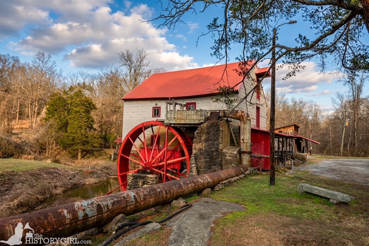
- Prallsville Mills: Located in Stockton along the feeder canal, this grist mill complex used the canal’s water for power.
- Activities: The towpath is flat and made of crushed stone, making it ideal for easy hiking and biking. You can rent canoes or kayaks in Princeton or Griggstown to see the canal from the water.
For More Information
D&R Canal Watch (www.canalwatch.org)
D&R Canal State Park (www.dandrcanal.com)

Leave a Reply